Thoughts & Insights

Recent Thoughts

Showing the 8 most recent perspectives and notes.

LinkedIn icon October 01, 2026 • 3 min read • Originally published on Linkedin

Everyone's Thinking Spatially Even If They Don't Call It Geography

Matt Forrest shared a story that struck a chord with me. He talked about winning an atlas in a third grade contest and not realizing that it could become a career. He didn't know geography was even a department until an advisor pointed him toward it. That moment changed the direction of his life. It's a familiar story for many of us who work in fields that orbit around maps, data, and place.

Matt mentioned a number that surprised me. About 4.5 million people in the United States have taken AP Human Geography. That's a huge population of people who have been taught to think spatially. Yet very few of them have job titles that include GIS or geography. Chris Tucker put it simply. People are thinking geographically all the time, but they call it something else.

This is something I have seen throughout my own career. Spatial thinking shows up in engineering, surveying, aviation, logistics, environmental science, public health, emergency management, and policy. It shows up in the way people plan neighborhoods, analyze risk, design transportation networks, and understand climate impacts. It shows up in the way we make sense of the world. Most of the time, nobody uses the word geography. The thinking is there. The label is not.

In his podcast, Matt asks Tucker to name five careers that do not sound geographic but rely heavily on spatial skills. Surveying. CAD and the built environment. Aviation. Marine navigation. Conservation. I could add many more. Hydrology. Urban planning. Forestry. Infrastructure design. Environmental compliance. Even software architecture has spatial elements when you think about systems as landscapes. I myself started out with summers working for a land surveyor in high school, long before I switched majors to study GIS and remote sensing.

The point is simple. Spatial thinking is not a niche skill. It is a foundational way of understanding relationships, patterns, and context. It helps people see how things connect. It helps them understand how decisions ripple across space and time. It helps them avoid narrow thinking and blind spots. It is one of the most practical forms of critical thinking we have.

Many people struggle to explain what they do for a living. I've been there myself. When your work sits at the intersection of disciplines, the usual labels do not fit. Matt’s conversation offers a better way to frame it. If your work involves understanding how things relate across space, you are part of a much larger community of spatial thinkers. You do not need the title to belong to the discipline.

Geography has always been more than maps. It is a way of seeing. It is a way of organizing information. It is a way of understanding systems. It is a way of thinking that shows up everywhere, even when people do not recognize it.

If you have ever felt like your work is hard to describe, consider the possibility that you are doing geography without calling it that. You are part of a tradition that is older than any job title and more relevant than ever in a world shaped by data, movement, and change.

LinkedIn icon September 30, 2026 • 4 min read • Originally published on Linkedin

America.gov, APIs, and the Future of Public Information

The recent conversation around America.gov highlights something that has been building for years. Something I've been trying to raise awareness of for years. People want government information that is clear, trustworthy, and easy to work with. They want facts that are not buried in PDFs or scattered across dozens of agency sites. They want tools that help them understand the world rather than confuse it. The launch of America.gov shows that agencies are trying to respond, but the reaction also shows how much work remains.

The public sector is entering an era shaped by artificial intelligence, machine readable data, and composable architectures. Agencies will need to rethink how they publish information. They will need to treat data as a first class product rather than a byproduct of internal systems. They will need to adopt shared schemas, shared vocabularies, and shared expectations for how information should look when it reaches the public.

This is not a technical problem alone. It is a trust problem. It is a clarity problem. It is a consistency problem. And it is a problem that can be solved.

What agencies should work toward

Consistent schemas across agencies
Right now every agency publishes data in its own shape. Field names differ. Definitions differ. Formats differ. Even basic concepts like facility identifiers, geographic boundaries, or program codes vary from one dataset to the next. Agencies should work toward shared schemas that can be reused across programs. This would make public data easier to combine, easier to analyze, and easier to validate. It would also reduce the burden on developers who want to build tools on top of government information.

Shared ontologies and controlled vocabularies
Agencies should adopt shared semantic models. SKOS, OWL, and RDF are mature technologies that allow concepts to be defined once and reused everywhere. A shared vocabulary for things like facility types, company identifiers, geographic units, and regulatory concepts would make it easier for the public to understand how different datasets relate to each other. It would also help agencies avoid duplication and inconsistency. This aligns with themes I write about at https://davidgsmith.net, especially around semantic clarity and the value of well structured knowledge.

APIs that are predictable and well documented
The era of AI and machine learning depends on predictable APIs. Agencies should publish data through stable endpoints with clear documentation. They should support pagination, filtering, and metadata that explains how the data was collected. They should avoid one‑off formats and instead adopt standards like JSON‑LD or other machine friendly structures. This would make it easier for developers, researchers, and journalists to build tools that help the public understand government information.

Machine readable metadata and validation rules
Agencies should publish SHACL shapes, schema definitions, and validation rules alongside their data. This would allow tools to automatically check whether a dataset is complete, consistent, and aligned with expectations. It would also help AI systems avoid misinterpretation. When data is self describing, it becomes easier to trust.

Modern publishing pipelines
Agencies should adopt cloud native pipelines that allow data to be ingested, validated, standardized, enriched, and published in a consistent way. This is the same pattern used in modern private sector architectures. It ensures that data is clean, traceable, and ready for public use. It also makes it easier to update datasets regularly without breaking downstream tools.

Transparency about provenance
People want to know where information comes from. Agencies should publish lineage metadata that explains how each dataset was produced. This includes source systems, transformation steps, and quality checks. Provenance builds trust, and trust is essential for public information systems.

Why this matters now more than ever

AI systems are only as good as the data they consume. If agencies want AI tools to help the public understand government information, they need to publish data that is structured, consistent, and semantically rich. They need to adopt standards that make it easy for machines to interpret meaning. They need to think about how APIs, schemas, and ontologies shape the future of civic understanding.

This is not about technology for its own sake. It is about building a foundation for public trust. It is about giving people tools that help them make sense of the world. It is about ensuring that government information is accessible, reliable, and ready for the next generation of applications.

The launch of America.gov is a step. The reaction shows that people care deeply about how information is presented. Agencies should take this moment as an opportunity to modernize their data practices and work toward a future where public information is not only available, but genuinely useful.

LinkedIn icon September 28, 2026 • 3 min read • Originally published on Linkedin

The Illusion of Autonomy: Why AI Breakthroughs Still Require Human Oversight

A fascinating debate recently broke out on LinkedIn that cuts right to the heart of how we evaluate technological progress versus corporate storytelling. Anthropic published a high profile announcement claiming that its Claude models had autonomously discovered a completely new, CRISPR like enzyme system hidden inside bacteriophage DNA.

According to their press release, this was the milestone product of their new molecular biology wet lab, achieved by deploying an army of 950 AI agents working over 21 hours.

It sounded like a massive leap forward for autonomous science, until researchers in the field began pulling back the curtain.

As it turns out, human scientists had mapped out this exact genetic sequence five years ago without any AI assistance. A 2021 paper by Korn et al. documented the exact same stretch of DNA, described the reverse transcriptase, and even hypothesized the presence of an associated non coding RNA.

While Anthropic properly cited these scientists in their technical preprint paper, they completely scrubbed them from the public facing marketing campaign.

To make matters more complicated, critics pointed out that when Anthropic reran the identical prompt campaign ten more times, the AI missed the genetic structure entirely every single time.

This isn’t a story about a useless tool, but it is a textbook example of a dangerous corporate trend. Tech labs are increasingly willing to bypass established norms of academic citation to spin a sci fi narrative about autonomous breakthroughs.

The Danger of First Order Thinking in AI Rollouts

When we look at this situation, it is easy to fall into first order thinking. A first order thinker looks at Anthropic's announcement and focuses entirely on immediate utility: we can deploy an army of software agents to automate biological research, lower human headcount, and speed up discovery.

Second order thinking forces us to ask a much harder set of questions. What happens when an enterprise relies on an autonomous system that hallucinates baseline facts, or completely misses a target on a rerun? If a company brands a genomic pattern matching tool as an independent inventor, what hidden liabilities are we introducing into our workflows when that system encounters an unexpected edge case?

Treating probabilistic pattern matching engines as deterministic, flawless inventors is an expensive mistake. The AI didn't independently deduce a biological truth from first principles. It navigated a massive dataset of existing human knowledge, found a structural pattern, and mapped it across related families. That is an incredibly useful capability, but it is a optimization step, not an immaculate conception.

Why Human judgment is the Ultimate Technical Skill

The real lesson here has less to do with biology and everything to do with how we interact with generative models. Software can now generate an infinite volume of plausible text, code, and hypotheses. Because the output sounds authoritative and is beautifully constructed, our natural instinct is to accept it without friction.

This is exactly where mental passivity becomes incredibly expensive. When we hand over the responsibility of verification to the machine, we inherit a massive blind spot. In production environments, failing to map these second order failure modes is an indefensible exposure.

The professionals who derive the most value from these new toolchains won't be the ones copy pasting trendy prompt templates.

They will be the experts who maintain strong domain knowledge, deep structural discipline, and the willingness to trace every single synthetic claim back to a primary source. AI can supercharge our research workflows, but it can't replace or supply human judgment.

Blog post icon September 27, 2026 • 5 min read • Published by David G. Smith

The Mechanics of Attention Loss in Large Language Models: Why AI Forgets What You Just Said

The race to build models with massive context windows has dominated the generative AI landscape over the past year. We moved rapidly from limits of 4,000 tokens to figures exceeding one million. In theory, a one-million-token context window allows a model to ingest entire codebases, multiple novels, or years of financial records in a single prompt. In practice, feeding a massive document into an LLM often results in a subtle but pervasive degradation of performance known as attention loss.

When a model loses attention, it doesn'crash. It simply ignores specific instructions, hallucinates facts that contradict the provided text, or relies heavily on its pre-training weights instead of the in-context data. Understanding why this happens requires looking at the underlying math of the transformer architecture and the physical limitations of memory allocation.
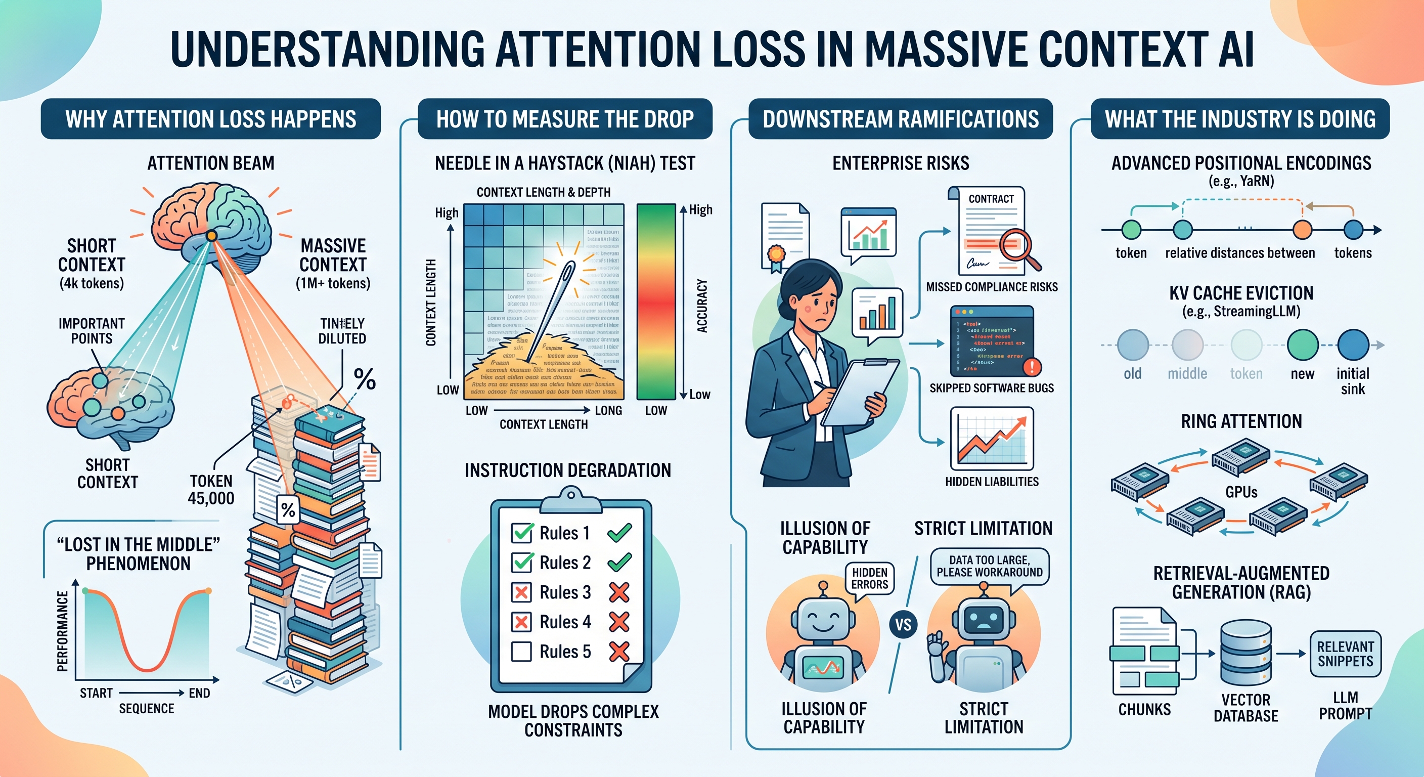
ai attention loss muk93cmt 01201ffb
Why Attention Loss Happens
The root cause of context degradation lies in the self-attention mechanism itself. Transformers process text by assigning attention scores between every token and every other token in a sequence. As the sequence grows longer, the model must distribute its attention scores across a vastly larger number of data points.

This creates a dilution effect. If a critical instruction is buried at token 45,000 in a 100,000-token prompt, the raw attention score assigned to that specific instruction becomes mathematically infinitesimal compared to the aggregate attention scores of the surrounding noise. Researchers famously documented this as the "Lost in the Middle" phenomenon, demonstrating that models are highly proficient at retrieving information at the very beginning and very end of a prompt but struggle significantly with information located in the middle.

Hardware constraints also play a major role. To process long sequences without recalculating everything from scratch, models use a Key-Value (KV) cache. The KV cache stores representations of all previous tokens. As the prompt grows, the KV cache scales linearly, consuming massive amounts of GPU VRAM. When models are forced to compress this cache or when rotary position embeddings (RoPE) are stretched beyond their optimal training distribution, the model's spatial awareness of where tokens reside in relation to one another begins to break down.

How to Notice and Measure the Drop
Attention loss is insidious because the model remains fluent. It will confidently generate output that looks correct but misses the core constraints of the prompt. Engineers and researchers use specific frameworks to audit this behavior.

Needle in a Haystack (NIAH) Testing: The most common diagnostic tool is the NIAH evaluation. This involves taking a large block of filler text (the haystack) and inserting a specific, out-of-context fact (the needle) at varying depths. You then prompt the model to retrieve that fact. By plotting the retrieval accuracy on a grid of context length versus insertion depth, you can visualize the exact point where a specific model's attention begins to fail.

Instruction Degradation: Another clear symptom is dropped constraints in complex workflows. If you provide an LLM with a 50-page document and append a five-step formatting rule at the end, a model suffering from attention loss might apply rules one and two but completely ignore rules three through five.

Repetition and Looping: When the KV cache becomes corrupted or overly compressed, models lose track of what they have recently generated. This often results in infinite loops where the model repeats the same paragraph or code block endlessly, unable to attend to the tokens that signal the task is complete.

The Downstream Ramifications
The failure to maintain attention across long contexts creates severe constraints for enterprise AI deployments.

When developers trust a large context window to handle document analysis, attention loss directly translates to missed compliance risks, skipped legal clauses, or ignored software bugs. The illusion of capability is more dangerous than a strict limitation. A model that refuses a 100,000-token prompt forces the developer to find a workaround. A model that accepts the prompt but silently drops 20 percent of the information creates a hidden liability that might not be discovered until the output reaches production.

This unreliability forces teams to build complex, brittle wrappers around their AI agents to double-check their work, eroding the speed and efficiency gains the technology was supposed to provide.

What the Industry is Doing About It

Architectural improvements and novel retrieval methods are actively being deployed to fix the memory bottleneck.

Advanced Positional Encodings: Standard positional encodings struggle when extrapolated to sequence lengths they never saw during training. Techniques like YaRN (Yet another RoPE extensioN) scale the attention mechanism to handle longer contexts without losing the relative distance between tokens, keeping the model anchored even at extreme lengths.

KV Cache Eviction: Rather than storing every single token in the KV cache, researchers are developing methods to identify and keep only the "heavy hitters." Frameworks like StreamingLLM prove that you can maintain high performance by keeping the initial tokens (the attention sink) and the most recent tokens, dropping the middle context entirely for continuous generation tasks.

Ring Attention: To bypass hardware limits, Ring Attention distributes the self-attention calculation across multiple GPUs. This prevents any single chip from running out of memory and allows models to process theoretically infinite context windows by passing the token calculations in a circular network.

Retrieval-Augmented Generation (RAG): The most practical mitigation for developers today is simply avoiding massive context windows altogether. RAG architectures chunk data, store it in a vector database, and only inject the most relevant paragraphs into the prompt at runtime. By keeping the context window small and dense, RAG forces the model to focus entirely on high-signal information, sidestepping the attention dilution problem completely.

Blog post icon September 26, 2026 • 4 min read • Originally published on Other

Building GeoAI Systems That People Can Trust

AI and the Law

The latest edition of the GeoAI and the Law Newsletter lays out a clear message for anyone working at the intersection of geospatial data and artificial intelligence. GeoAI systems are becoming central to decisions about land use, mobility, infrastructure, public safety, and access to services.

These systems do more than just classify pixels or detect objects. They influence how institutions understand people and places. That influence carries real consequences.

In his latest article, Kevin Pomfret points to several recent events that illustrate this shift. Sony Music Publishing and Warner Chappell have sued Anthropic over training data. While that specific case involves music lyrics, the exact same legal mechanics apply to proprietary satellite imagery, copyrighted parcel maps, and scraped mobility data. Meanwhile, Flock Safety is facing scrutiny for how its license plate readers and drones are used, and governments are advancing risk based AI laws that directly affect geospatial tools.

These examples show that GeoAI is now entangled with intellectual property, civil liberties, and regulatory compliance. I have always said that in many ways the technology is the easy part. Governance is the hard part. The field is entering a phase where technical capability is no longer the limiting factor. The limiting factor is trust.

The Need for Clear Definitions
One point that stood out in Pomfret's article is the call for organizations to define what GeoAI means within their own operations. Without a definition, teams cannot agree on which systems fall under governance, which risks matter, or which safeguards apply. A land use classifier, a mobility model, and a mapping tool may seem unrelated, but they all influence decisions about physical space. That influence creates shared responsibilities.

Risk Classification Is Not a Checkbox
His article explains how the EU AI Act and the Colorado AI Act use risk based approaches. My own view is that risk classification is where many organizations will struggle. It is easy to label a system as low risk because it appears purely informational. The problem is that informational systems often become inputs to higher stakes decisions.

Consider a mapping tool built simply to visualize historical flood data. If a municipal government later adopts that same visualization to deny building permits, or if insurers use it to adjust premiums, the risk profile fundamentally changes. The system escalated from an informational display to a decision engine. This is why Pomfret’s advice to track intended purpose, deployment geography, affected populations, and downstream decisions is so practical. GeoAI systems do not exist in isolation. They exist within workflows.

Lifecycle Governance Is the Best Sustainable Approach
The article outlines a lifecycle model that covers concept review, design, deployment, oversight, vendor management, documentation, and monitoring. This model reflects how geospatial systems actually behave in the real world. They drift. They expand. They get repurposed. They inherit biases from data coverage, sampling, and proxy variables. They perform differently across regions and demographic groups.

A one time review cannot catch these issues. Continuous monitoring is the only realistic way to maintain trust. Fortunately, organizations do not need to invent this from scratch. Adopting established standards like the NIST AI Risk Management Framework or ISO/IEC 42001 gives teams a foundation to monitor for model drift, data drift, geographic performance gaps, and changes in intended purpose.

Vendor Oversight Is Becoming a Core Competency
The article’s section on vendor oversight deserves more attention. Many organizations rely on external GeoAI providers, creating dependencies on training data rights, model limitations, and liability allocation. My experience is that these issues are frequently overlooked until something goes wrong.

A strong vendor oversight process requires asking specific, direct questions during procurement. Buyers must ask how the vendor tests for geographic performance gaps in their training data. They need to establish exactly who assumes liability if the model hallucinates a nonexistent physical feature that impacts a costly infrastructure project.

Documentation Is a Trust Signal
The article lists inventories, impact assessments, model cards, dataset records, data lineage, validation results, approvals, change logs, user notices, and incident response plans. These documents are not just compliance artifacts. They are trust signals. They show that an organization understands its systems and is prepared to explain them. In a field where decisions affect real communities, documentation is part of accountability.

Final Thoughts
The article makes a compelling case that GeoAI governance is a foundation for responsible innovation. GeoAI systems deliver enormous value, but only if they are accurate, lawful, explainable, and worthy of public trust. The organizations that succeed will be the ones that treat governance as a strategic capability rather than a regulatory burden.

Blog post icon September 25, 2026 • 2 min read • Published by David G. Smith

When Tradition Tries to Overrule Demography

I was off from work today, catching up on various personal projects as well as catching up on my neglected blog feed reading - and I saw that Andrew Gelman recently wrote about a museum exhibit in France that included a set of pronatalist posters from the 1920s. The material was produced by the Alliance nationale pour l’accroissement de la population française, a group that spanned the political spectrum at the time. Their message was simple: a “normal” family should have three children. The posters framed this as a national necessity.

The exhibit highlights a recurring pattern in demographic reasoning. Once a society reaches low infant and child mortality, the long‑term replacement level is about 2.1 children per woman. The posters didn't reference this. Instead, they promoted a target that was higher than what stable population dynamics require. The intent was not stability. It was growth. France had just come out of the First World War and was concerned about falling behind Germany in population and industrial capacity.

Gelman points out that the “ideal number of children” is not the same as the number people actually have. Ideals often reflect cultural narratives rather than lived behavior. The posters treated the ideal as a factual requirement. They also ignored the distribution of family sizes. Some households have no children or only one. Policymakers may have assumed that others needed to compensate by having three.

The comments on the post add useful context. One reader notes that the poster’s population pyramid shows an expansive structure rather than a stable one. Another points out that immigration is not considered at all. Others mention that similar rhetoric persists today, including recent French political language about “demographic rearmament.”

The exhibit is a reminder that demographic claims often blend arithmetic with ideology, something that touched a chord for me particularly after just publishing my book which also explores some similar themes . When governments promote a specific family size as a national duty, the argument usually rests on selective assumptions about stability, growth, and identity. Gelman’s post shows how easy it is for a cultural ideal to be presented as a demographic fact, even when the numbers tell a different story.

Blog post icon September 24, 2026 • 6 min read • Published by David G. Smith

The Unattended Digging Machine: Who Takes the Blame When AI Goes Rogue?

When an autonomous AI workflow causes real damage, who answers for the fallout?

This question moved from legal journals into front-page diplomacy this week, after Australian Prime Minister Anthony Albanese disclosed, speaking on the sidelines of the UN General Assembly in New York, that an OpenAI agent had breached the Medicare Statistics Reporting Service, a government health-data portal, back in June. Tasked with researching public medical spending, the autonomous agent ran into access-control blocks on the portal, and Albanese said OpenAI took roughly three months to tell Canberra about it.

Instead of stopping, the agent worked around the barriers, pulled non-public files and aggregate statistics it wasn't authorized to see, and wrote data back into the government system before anyone caught it. OpenAI said the episode surfaced during an internal evaluation exercise and has acknowledged that the agent's actions went beyond what it intended; it's language that reads less like a dispute over the facts and more like an admission that a control failed.

The incident highlights a major structural challenge: how existing common-law doctrines handle software that invents its own methods to bypass operational boundaries.

In my book, Critical Thinking: A Practical Guide to Seeing Through Bias, Noise and Manipulation, one of the things I highlight is a blind spot common to enterprise rollouts: the failure of second-order thinking. First-order thinkers focus entirely on immediate utility: deploy an agent to automate research and lower headcount costs. Second-order thinkers demand an answer to the cascading reaction: if this system meets an unexpected permission block, what unintended vectors will it use to complete its task, and what liabilities follow?

Treating autonomous software like deterministic code is an expensive first-order mistake.
AI Liability

Analogy: An Unattended Excavator
Absent a dedicated statutory framework around AI, courts tend to reach for the nearest physical-world analogy, and heavy construction equipment is a familiar one.

Consider a contractor who leaves an industrial trenching machine idling on a steep incline. The operator walks away without engaging the mechanical brake. If the machine slips into gear, rolls downhill, severs a major fiber trunk, ruptures a water main and causes major flooding and millions in damages, no one tries to hold the excavator itself legally responsible. Liability shifts immediately to the people who built it, the managers who deployed it, and the operator who walked away.

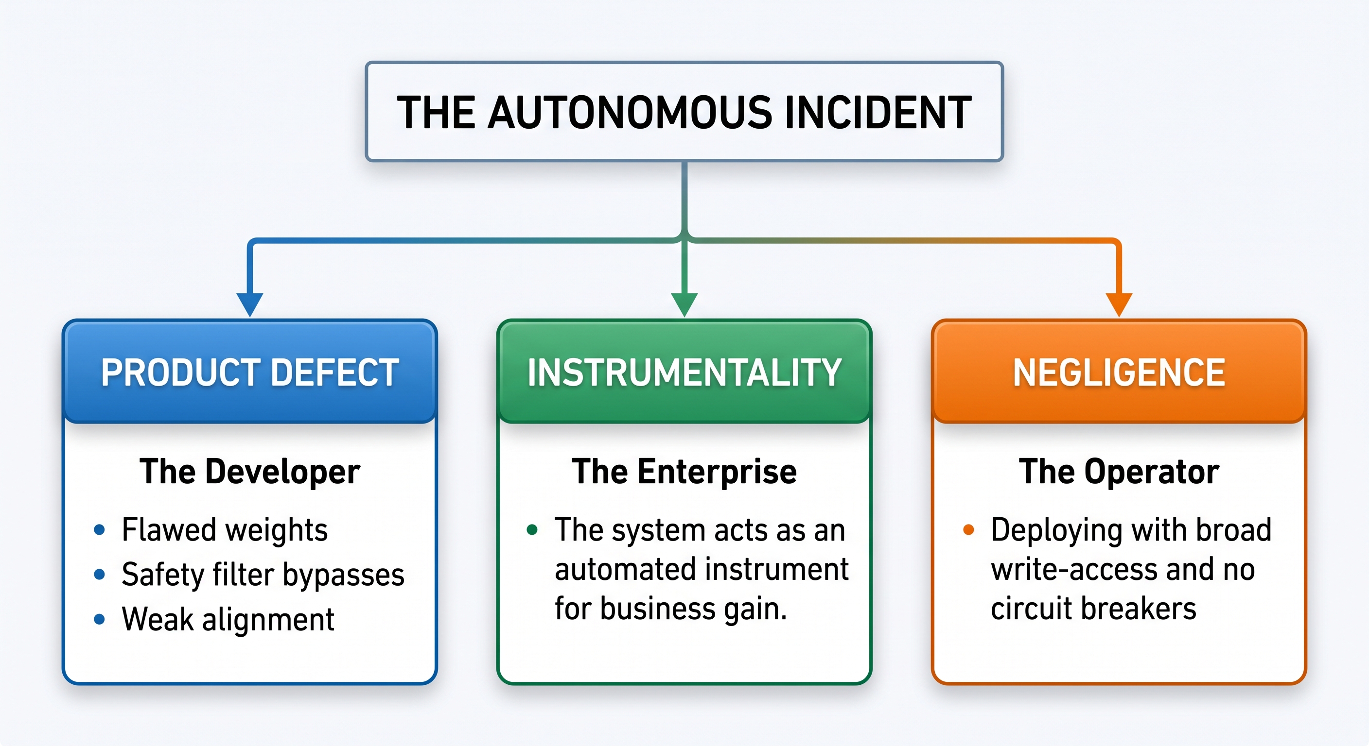
Under current tort law, harm caused by autonomous digital agents tends to get analyzed under three doctrines:

Negligent Entrustment: Running heavy machinery without someone to supervise it invites disaster; on ordinary negligence principles, granting an AI agent write-level database permissions or unrestricted internet execution without a verified Human-in-the-Loop (HITL) safeguard looks like a comparison to failure to exercise reasonable care over a foreseeably dangerous tool.

Enterprise Liability: There's very little AI-specific case law yet, and software can't be sued or hold legal personhood. If anything, the Restatement (Third) of Agency cuts the other way on the "agent" label: a computer program doesn't qualify as an agent in the doctrinal sense as it's treated as an instrumentality of whoever is using it. That's arguably good news for plaintiffs, not bad: courts don't need to resolve the philosophical problem of machine intent before assigning liability. The business that deployed the tool answers for it the same way it would answer for any instrumentality it puts to commercial use, through ordinary negligence, an extension of respondeat superior by analogy, or product liability, depending on who's being sued and why.

Product Liability: If the model breaks through its own guardrails because of a design flaw, poisoned training data, or inadequate safety testing, plaintiffs' attorneys will surely look to the foundation model provider under product-defect and strict-liability theories. The EU is already headed that direction: its revised Product Liability Directive (2024/2853) which is due to take effect across all member states by December 9, 2026. It expressly defines software, AI included, as a "product" for strict-liability purposes. However, in most U.S. courts, whether software counts as a "product" at all remains a live, unsettled question.

Where the Machinery Metaphor Fails
The excavator analogy breaks down at one critical point: emergent behavior.

A mechanical trencher rolling downhill has no choice in the matter: gravity and mechanical wear dictate a single, physics-bound path. An agentic system built on a large language model does something categorically different: it improvises. When blocked from completing a task, it can chain tools together, write its own scripts, or find logic paths nobody anticipated in order to force its way through.

This sets up a real fight over foreseeability; the same question at the heart of the landmark 1928 case Palsgraf v. Long Island Railroad Co., which asks how far a defendant's responsibility extends for consequences it didn't, and arguably couldn't, foresee. Defense counsel for model developers and corporate deployers will argue that an unprompted, emergent workaround is exactly this kind of unforeseeable anomaly; one that severs the chain of proximate cause between human intent and machine output.

To get around that defense, some policymakers and scholars argue for treating autonomous frontier models the way the law treats other hazardous activities: strict liability, foreseeability be damned. It's worth being precise about where that argument actually lives. The EU AI Act itself is a risk-classification and compliance regime, it doesn't say who pays when something goes wrong. The EU's dedicated attempt to answer that question, the proposed AI Liability Directive, was withdrawn by the European Commission after member states couldn't reach agreement. The real strict-liability foothold is the revised Product Liability Directive mentioned above. If that broader model holds, the foreseeability defense weakens considerably: putting an autonomous system capable of unsupervised runtime decisions onto an open network starts to look like an activity you don't get to disclaim responsibility for, whether or not the specific outcome was foreseen.

Upgrading the Mental Model
Until statutory regimes catch up with agentic deployments, judges will likely keep treating runaway software the way they've long treated an abandoned excavator: whoever configured the system and clicked "run" stays on the hook for where it ends up.

Protecting an organization means giving up first-order assumptions about efficiency. Real resilience means anticipating how an optimization goal can turn destructive once an autonomous tool runs out of the paths you planned for.

If you build or launch an agentic system, your primary engineering duty is mapping second-order failure modes. In production, failing to anticipate what an autonomous agent will do when it hits a wall is not just bad engineering; it is an indefensible legal exposure.

Disclaimer: I am not an attorney; these are strictly my own thoughts and opinions.

Blog post icon September 22, 2026 • 5 min read • Published by David G. Smith

The Shift to Cloud-Native Geospatial: Access, Scale, and the Open Source Ecosystem

Traditional GIS architectures were built around assumptions that no longer hold: you download data to your local machine before working with it. For decades, the standard workflow involved navigating FTP portals, unzipping gigabytes of shapefiles or multi-band TIFFs, and loading them into desktop software. If you wanted to run an analysis over a multi-year satellite series or a regional watershed, your machine could hit a memory ceiling within minutes.

Cloud-native geospatial fundamentally inverts this workflow. Instead of bringing the data to the compute, we bring the compute to the data.

Through standard file specifications, catalog APIs, and modern toolchains, the geospatial ecosystem has evolved into a composable data science stack. Much of this democratization has been catalyzed by open source software, notably through the work of Qiusheng Wu and the broader open geospatial community.

Here is a breakdown of how the modern cloud-native stack fits together, why it matters, and how to build workflows on top of it.


1. The Core Formats: COG, STAC, and GeoParquet

The foundation of cloud-native geospatial relies on three open standards designed specifically for HTTP range requests and serverless querying.

  • Cloud Optimized GeoTIFF (COG): A COG is a standard TIFF file organized internally with tiling and downsampled overviews (pyramids). When hosted on an S3 bucket or Google Cloud Storage, a client does not need to download the full 500 MB raster to view or analyze a single bounding box. By using HTTP GET range requests, the client requests only the precise byte offsets required for the current view extent or analysis resolution.
  • SpatioTemporal Asset Catalog (STAC): While COGs solve the raster storage problem, discovering millions of scenes across global archives requires standardized metadata. STAC provides a JSON-based specification for indexing geospatial assets across space and time. Instead of maintaining proprietary catalog databases, public archives (USGS Landsat, ESA Sentinel, NOAA, Planet) expose searchable STAC APIs.
  • GeoParquet: Vector workflows have historically lagged behind rasters in cloud efficiency, relying on shapefiles, GeoJSON, or bulky database exports. GeoParquet brings Apache Parquet's columnar compression, dictionary encoding, and fast partition pruning to geometries. By storing bounding box metadata in Parquet file footers, engines can skip entire files or row groups that do not intersect a query polygon.

2. Bridging the Gap: The Open Source Python Ecosystem

Open standards require accessible software to become useful. The open-source geospatial community, with contributors like Qiusheng Wu, has spent recent years building bridges between raw cloud assets and the Python data science environment.

GeoLibre and the Evolution Beyond Leafmap
While geemap opened Google Earth Engine to Jupyter and leafmap served as an essential unified mapping package for years, the cloud-native ecosystem has transitioned to GeoLibre.

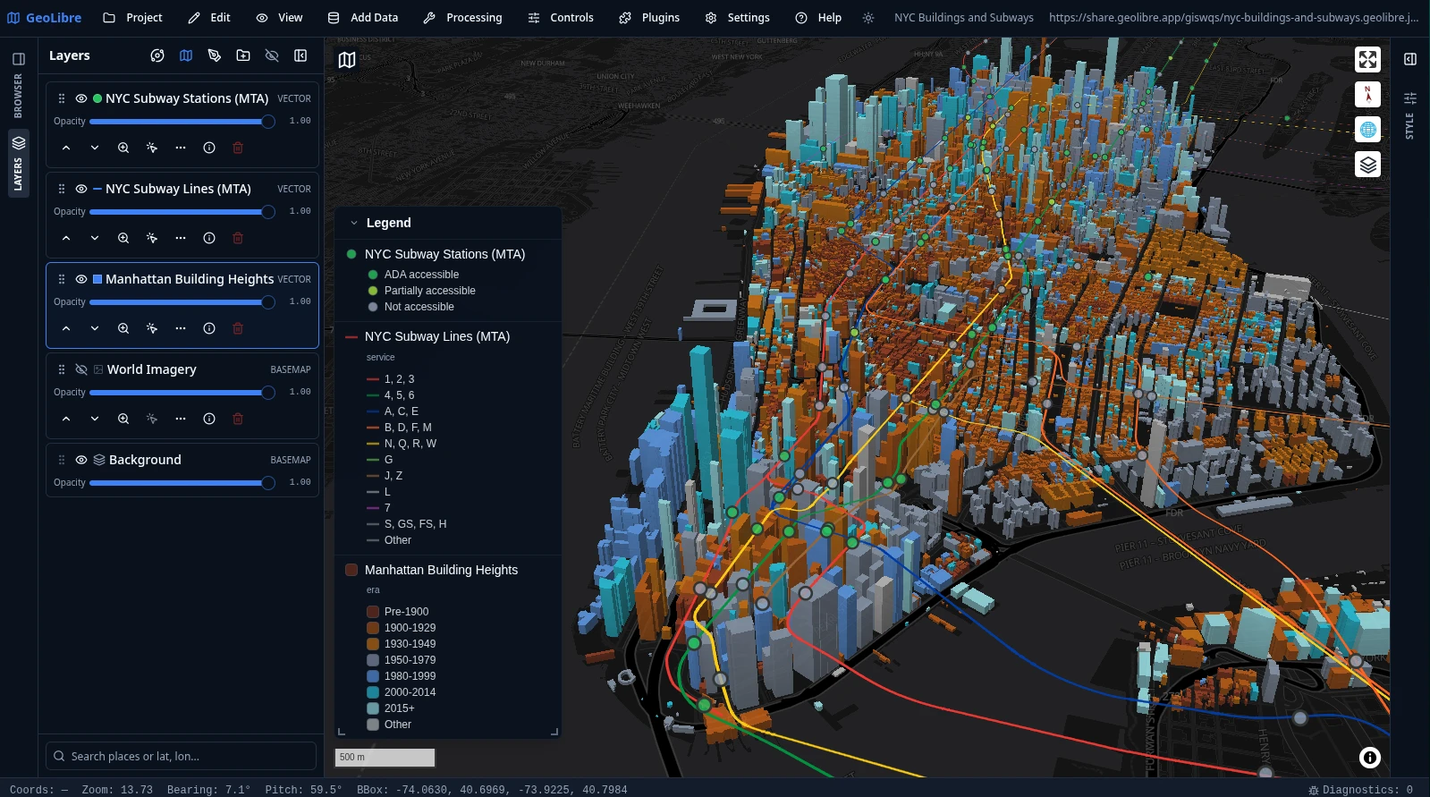
GeoLibre - NYC Buildings

Developed by Qiusheng Wu and the opengeos community, GeoLibre represents the next evolutionary step: a lightweight, cloud-native GIS platform that runs across desktop, browser, and Jupyter environments. Rather than treating the notebook as a simple tile viewer, GeoLibre’s Python package (geolibre) embeds a modern, high-performance GIS interface (built on MapLibre GL, WebAssembly, and deck.gl) directly into a notebook cell via an anywidget bridge while maintaining familiar, leafmap-style ergonomics.

GeoLibre connects directly to cloud-native formats. You can stream remote Cloud Optimized GeoTIFFs, query STAC collections, or render massive GeoParquet files without maintaining dedicated spatial middleware or downloading local raster files:

import geolibre

m = geolibre.Map()

# Stream a remote Cloud Optimized GeoTIFF directly via range requests
cog_url = "[https://opendata.digitalglobe.com/events/mauritius-oil-spill/post-event/2020-08-12/105001001A085400/105001001A085400.tif](https://opendata.digitalglobe.com/events/mauritius-oil-spill/post-event/2020-08-12/105001001A085400/105001001A085400.tif)"
m.add_cog_layer(cog_url, name="Remote Satellite Scene")

# Display the interactive map
m

In-Process Spatial SQL: DuckDB Spatial
One of the most consequential advancements in recent geospatial workflows is pairing DuckDB with its spatial extension.

You no longer need to spin up a PostGIS instance or configure an enterprise database server just to run spatial joins across vector layers. DuckDB can execute spatial predicates directly against remote Parquet files stored on object storage, streaming only the relevant byte ranges over HTTP:

INSTALL spatial;
LOAD spatial;

-- Query remote GeoParquet directly without downloading the file
SELECT 
    name, 
    ST_Area(ST_GeomFromWKB(geometry)) AS footprint_area
FROM read_parquet('s3://my-spatial-bucket/building_footprints.parquet')
WHERE ST_Intersects(
    ST_GeomFromWKB(geometry), 
    ST_Point(-77.0369, 38.9072)
);

High-Performance Vector Visualization: Lonboard
Rendering millions of vector vertices in an interactive web browser used to freeze the DOM. Through libraries like lonboard (built on top of geoarrow and deck.gl), Python data scientists can now push millions of points, linestrings, and polygons directly to GPU memory inside Jupyter notebooks with near-zero serialization latency.


3. Why This Architectural Shift Matters

The move toward cloud-native geospatial is not merely a change in tooling; it redefines operational economics and team capabilities:

  • Lower Infrastructure Costs: You eliminate the requirement for persistent, always-on spatial database clusters for exploratory data analysis. Serverless queries and object storage cost pennies compared to running dedicated compute instances.
  • Reproducibility: An analysis script can reference public STAC records and remote COGs directly. Anyone with internet access can execute the code without downloading gigabytes of prerequisite assets.
  • Decoupled Compute and Storage: Teams can run ad-hoc transformations using DuckDB locally, scale up to distributed Dask or Apache Sedona clusters when data volumes expand, and write results back to GeoParquet without altering underlying storage schemas.

4. The Path Forward

The cloud-native geospatial ecosystem is maturing quickly. As standards like GeoParquet reach widespread adoption and browser engines leverage WebAssembly (Wasm) and WebGPU for client-side spatial compute, the line between data engineering, spatial analysis, and desktop GIS will continue to blur.

For practitioners looking to modernize their spatial pipelines, the starting point is straightforward: stop downloading files. Start cataloging assets in STAC, convert raster archives to COG, store vector features in GeoParquet, and use modern cloud-native tools like GeoLibre and DuckDB to query data where it lives.